


Red Stripe Voting District, Stone County, Arkansas
About
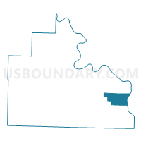
Outline

Summary
| Unique Area Identifier | 528272 |
| Name | Red Stripe Voting District |
| County | Stone County |
| State | Arkansas |
| Area (square miles) | 15.16 |
| Land Area (square miles) | 14.97 |
| Water Area (square miles) | 0.19 |
| % of Land Area | 98.77 |
| % of Water Area | 1.23 |
| Latitude of the Internal Point | 35.81658950 |
| Longtitude of the Internal Point | -91.91279320 |
Maps


Graphs
Select a template below for downloading or customizing gragh for Red Stripe Voting District, Stone County, Arkansas


Neighbors
Neighoring Voting District (by Name) Neighboring Voting District on the Map
- Arbana Voting District, Stone County, AR
- Franklin Voting District, Stone County, AR
- Marcella Voting District, Stone County, AR
- Washington Voting District, Independence County, AR
Top 10 Neighboring County Subdivision (by Population) Neighboring County Subdivision on the Map
- Washington township, Independence County, AR (969)
- Arbana township, Stone County, AR (861)
- Franklin township, Stone County, AR (547)
- Red Stripe township, Stone County, AR (340)
- Marcella township, Stone County, AR (229)